
Slope prioritisation (Malaysia)
The estimation of potential slope stability risk along a highway is important for the establishment of slope maintenance expenditure planning. It is possible to use survey techniques such as LiDAR and Digital Video Geographics to deliver topographic data for slope profile definition along a highway and to add soil and geotechnical data such that sufficient data can be obtained to configure CHASM.
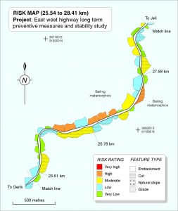
Application of CHASM to each slope profile using specified return period rainfall drivers can thus yield an estimate of Factor of Safety map for a length of highway. Such a map can aid the spatial identification of those slopes to which expenditure in terms of preventative maintenance could be most profitably directed. Additionally, if such expenditure were to be capped, the potential consequences of non-expenditure can be explored.
Scenario modelling can be undertaken using, for example, the vegetation module to ascertain the relative impact that changing [removal or planting] of different surface covers might conceivably have on such maintenance expenditure profiles.
References
- Lloyd, D.M., Anderson M. G, Husseian, A. N., Jamaludin, A. & Wilkinson P. L, (2001) Preventing landslides on roads and railways: a new risk-based approach. Civil Engineering ICE , 144, 129-134
- Jamaludin, S., & Hussein, AN. (2006) Landslide hazard and risk assessment:The Malaysian experience. IAEG2006 Paper number 455