
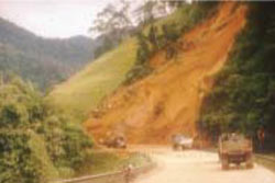
Topographic controls (Malaysia)
Slope plan form can have a very significant effect on the pore pressure distribution throughout a slope. A slope plan form that is convergent will result in higher pore pressures at the slope base than a slope having a divergent slope plan from. Convergent slope plan form will be inductive to the generation of preferentially saturated conditions and have thereby a greater likelihood of resultant slope instability:
This topographic control on pore pressure and slope stability can be clearly observed on road cut slope construction sites, where for example immediately adjacent contrasting slope plan forms exhibit failure and apparent stability: 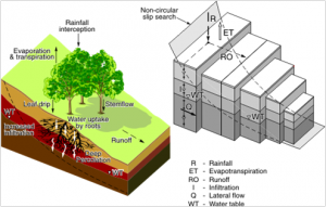
Field evidence of this form shows the importance of incorporating, even in an approximated form, the influence of the ‘third dimension’ as far as pore pressure is concerned.
Within the finite diference structure, CHASM allows for variable slope cell ‘breadth’ to be defined. From either the slope draw function or the main dialogue window a slope cross-section can be established. For each resultant cell, a width can be specified to create overall slope convergence, divergence or a more complex topographic representation. The slope stability analysis search is always undertaken in two dimensions using the single, slope  centred computational points.
Topographically controlled divergent and convergent soil water conditions can thereby be approximated using CHASM and the effect of topographic controls on stability can be explored